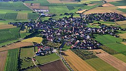
Gnotzheim
|
Chest artícol a l'è scricc in Lumbàrt, ortograféa orientàl unificàda. |
| Gnotzheim Comun | |||||
|---|---|---|---|---|---|
| |||||
 | |||||
| Dats aministrativ | |||||
| Stat | Germania | ||||
| Land | Baviera | ||||
| Distret | |||||
| Circondari | |||||
| Politega | |||||
| Sindegh | |||||
| Territore | |||||
| Coordinade | 49°03′31.18″N 10°42′43.31″E / 49.05866°N 10.71203°E | ||||
| OSM | 1015102 | ||||
| Voltituden | 473 m s.l.m | ||||
| Superfix | 12,48 km² | ||||
| Abitants | 845 ab. (31 dicember 2022) | ||||
| Densitaa | 67.71 ab./km² | ||||
| Confin | Ansbach, Gunzenhausen, Dittenheim, Heidenheim e Westheim | ||||
| Fus orari | UTC+01:00 e UTC+02:00 | ||||
| Varie | |||||
| Prefiss | 09833 | ||||
| Codex postal | 91728 | ||||
| Sigla autom. | WUG | ||||
| Cl. climatega | |||||
| Cl. sismega | |||||
| Localizazion | |||||
 | |||||
| Sit istituzional | |||||
Gnotzheim l'è 'n cümü todèsch del stat federàl (Bundesland) de la Baviera, distrèt (Regierungsbezirk) de la Média Francònia. El pórta 'l tìtol de Mercàt (Marktgemeinde) che völ dì che 'l reprezènta 'n cèntro de importànsa piö grànda de 'n cümü normàl. El fà part del circondare rüràl (Landkreis) de Weißenburg-Gunzenhausen. La süperfìce del teretóre aministràt del cümü l'è de 12.48 km² e 'ndel Desember 2016 el gh'ìa 'na popolasiù de 804 abitàncc.
El cümü de Gnotzheim el se tróa a 'na altèsa de 473 méter sura 'l leèl del mar.
Riferimèncc[Modifega | modifica 'l sorgent]


