
Bayreuth
|
|
Chest artícol a l'è scricc in Lumbàrt, ortograféa orientàl unificàda. |
| Bayreuth Comun | |||||
|---|---|---|---|---|---|
| |||||
 | |||||
| Dats aministrativ | |||||
| Nom ofiçal | Bayreuth | ||||
| Stat | Germania | ||||
| Land | Baviera | ||||
| Distret | |||||
| Circondari | |||||
| Politega | |||||
| Sindegh | Thomas Ebersberger | ||||
| Territore | |||||
| Coordinade | 49°56′53″N 11°34′42″E / 49.948056°N 11.578333°E | ||||
| OSM | 62640 | ||||
| Voltituden | 344 m s.l.m | ||||
| Superfix | 66,89 km² | ||||
| Abitants | 74 907 ab. (31 dicember 2023) | ||||
| Densitaa | 1119.85 ab./km² | ||||
| Confin | Bayreuth | ||||
| Fus orari | UTC+01:00 e UTC+02:00 | ||||
| Varie | |||||
| Prefiss | 921, 9201 e 9209 | ||||
| Codex postal | 95401–95448 | ||||
| Sigla autom. | BT | ||||
| Cl. climatega | |||||
| Cl. sismega | |||||
| Localizazion | |||||
.svg) | |||||
| Sit istituzional | |||||


Bayreuth l'è 'na cità todèsca sitüàda 'ndèl Land de la Baviera, 'ndèl distret de l'Alta Francònia.
Bayreuth l'è 'na cità extra-circondariàl (kreisfreie Städte) che völ dì che la fà circondàre (Kreis) de per sò cönt. El distrèt omònim el g'ha séde 'n cità, ma la cità la na fà mìa part.
Informasiù generài
[Modifega | modifica 'l sorgent]Bayreuth l'è übicàda söl fiöm Méno Rós (Roter Main, giü de i dù ram che i fùrma 'l Méno), 'ntra i mucc del Fichtelgebirge e l'altipià ciamàt Svìsera Francùna. Se pènsa che la cità la sàpe stàda fondàda dei Cónti de Andechs, facilmènt entùren a la metà del sècol XII[1], ma l'è stàda mensiunàda per la prìma ólta 'ndèl an 1194 col nòm de Baierrute endèn docümènt del Vèscof Otto II de Bambèrga. La pàrt finàl -rute la pödarès significà Rodung o "radüra", 'nvéce Baier- 'l signìfica "imigràncc de la regiù de la Baviéra", isé a mèter ensèma töt, a stà a chèsta ricustrusiù, Bayreuth el pödarès significà argóta come "Piana dei Bavarés".
Südiviziù 'n circuscrisiù
[Modifega | modifica 'l sorgent]El teretóre de la cità de Bayreuth l'è spartìt en 39 circuscrisiù:
- 1: Westliche Innenstadt
- 2: Östliche Innenstadt/Obere Röth
- 3: Cosima-Wagner-Straße/ Nürnberger Straße/Universitätsstraße
- 4: Südöstliche Innenstadt
- 5: Südwestliche Innenstadt
- 6: Birken
- 7: Justus-Liebig-Straße/Quellhöfe/Rückertweg
- 8: Leuschnerstraße/Ludwig-Thoma-Straße
- 9: Saas
- 10: Bismarckstraße/Friedrichstraße/Moritzhöfen
- 11: Freiheitsplatz/Malerviertel
- 12. Erlanger Straße/Wolfsgasse
- 13: Jakobshof
- 14: Hetzennest/Braunhof/Fantaisiestraße
- 15: Meyernberg
- 16: Nördlicher Roter Hügel
- 17: Grüner Hügel/Wendelhöfen
- 18: Kreuz
- 19: Herzoghöhe/Am Bauhof
- 20: Nördliche Innenstadt
- 21: Carl-Schüller-Straße/Bürgerreuther Straße/Gutenbergstraße
- 22: Gartenstadt
- 23: Bürgerreuth/Gravenreutherstraße
- 24: St. Georgen/Grüner Baum/Burg
- 25: Östliche Hammerstatt
- 26: Westliche Hammerstatt
- 27: Bernecker Straße/Insel/Riedelsberg
- 28: Industriegebiete St. Georgen
- 29: St. Johannis
- 30: Neue Heimat
- 31: Oberkonnersreuth
- 32: Laineck
- 33: Westlicher Roter Hügel
- 34: Eubener Straße/Furtwänglerstraße/Schupfenschlag/Hohe Warte
- 35: Seulbitz
- 36: Aichig/Grunau
- 37: Thiergarten/Destuben
- 38: Oberpreuschwitz
- 39: Wolfsbach
Cità 'nzemelàde
[Modifega | modifica 'l sorgent]
Bayreuth l'è 'nzemelàda co le cità de:
- Annecy, Francia, del 1966
- Rudolstadt, Türingia, del 1990
- La Spezia, Italia, del 1999
- Distrèt nömer 6 de Pràga, Repüblica Céca, del 2008
Galerìa de fóto
[Modifega | modifica 'l sorgent]-
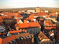 Panoràma de Bayreuth vést de la Stadtkirche
 -
 La Stadtkirche
 -
 El palàs nöf
 -
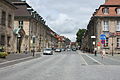 Friedrichstrasse


Riferimèncc
[Modifega | modifica 'l sorgent]- ↑ Mayer, Bernd and Rückel, Gert (2009). Bayreuth - Tours on Foot, Heinrichs-Verlag, Bamberg, p.5, ISBN 978-3-89889-147-9.