
Archivi:Republic of Venice 1789.svg

Grandezza de quetsa presualizzazion PNG per quell fail SVG chì: 450 × 456 picsel. Alter risoluzzion: 237 × 240 picsel | 474 × 480 picsel | 758 × 768 picsel | 1 011 × 1 024 picsel | 2 021 × 2 048 picsel.
Fail orginal (archivi in formad SVG, grandezza nominal 450 × 456 picsel, grandezza de l'archivi: 927 KByte)
Somari


.svg)
.svg)
.svg)
.svg)
.svg)


.svg)
.svg)
.svg)


.png)
.png)


.svg)


.svg)

.svg)


.svg)
.svg)
.svg)
.svg)


.svg)
.png)


.svg)


.svg)
.svg)


.svg)


.svg)


.svg)
.svg)
.svg)
.svg)
.svg)
.svg)
.svg)
_cropped.svg)
.svg)
.svg)
.svg)
.svg)
.svg)
.svg)
.svg)
.svg)
.svg)
.svg)
.svg)
.svg)
.svg)
.svg)
.svg)
.svg)
.svg)
.svg)
.svg)
.svg)
.svg)
.svg)
.svg)
.svg)
.svg)
.svg)
.svg)
.svg)
.svg)
.svg)
.svg)
.svg)
.svg)
.svg)
.svg)
.svg)
.svg)
.svg)
.svg)
.svg)
.svg)
.svg)
.svg)
.svg)
.svg)
Licenza
Mi, titolar del dirit d'autor, deciari de publicala sota questa licenza chìː
Quell fail chì l'è concedud in licenza sota la licenza Creative Commons Attribution-Share Alike 3.0 Unported
- Te see liber:
- de spartì con di alter persone – de copià, mandà in gir e trasmeter el lavorà
- de organizzà de noeuv – de adatà el lavorà
- Sota 'sti condizzion chì:
- atribuzzion –
Te gh'hee de fornì i sgiust credit, un conligament a la licenza e insegnà semai che ghe sien stad portad di cambiament. Te podet fall in una quaisevoeur manera rasgionevol, ma minga d'ona manera che la sugerissa che l'autor approva ti o la toa utilizazzion.
- spartiss con di alter persone a l'istessa manera. – Se ti te mett insema messedand, te transformet, o te scrivet sgiò el material, te gh'hee de mandà in gir i tò contribuzzion sota la same or compatible licens come l'original.
Register original del caregament
This image is a derivative work of the following images:
- File:Europe_1789.svg licensed with Cc-by-sa-3.0
- 2013-04-14T03:44:26Z Alphathon 450x456 (858577 Bytes) Corrected some errors in northern Italy
- 2013-04-14T01:38:01Z Alphathon 450x456 (853881 Bytes) tweaked again
- 2013-04-14T01:36:10Z Alphathon 450x456 (853881 Bytes) Tweaked Holy Roman Empire border style
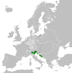
- 2013-04-14T01:33:26Z Alphathon 450x456 (853857 Bytes) == {{int:filedesc}} == {{Information |Description={{en|A blank Map of Europe circa 1789. This map also includes a border for the [[:en:Holy Roman Empire|Holy Roman Empire]]. Since there are so many small German states, they h
Uploaded with derivativeFX
Cronologia de l'archivi
Schiscia in su un grup data/ora per vedè l'archivi com 'a l'è che l'era in quell moment là
| Data/Ora | Miniadura | Grandezza | Utent | Coment | |
|---|---|---|---|---|---|
| corent | 00:20, 27 nov 2021 | | 450 × 456 (927 KByte) | Cplakidas | Fixing Venetian Albania, adding Cythera to Venice |
| 09:55, 17 oto 2021 |  | 450 × 456 (803 KByte) | Fenn-O-maniC | Fixed the Russo-Swedish border to match the Treaty of Åbo of 1743 | |
| 11:23, 27 feb 2020 |  | 450 × 456 (821 KByte) | Facquis | Clear map | |
| 19:16, 18 avr 2013 |  | 450 × 456 (820 KByte) | Alphathon | Various fixes | |
| 05:54, 14 avr 2013 |  | 450 × 456 (802 KByte) | Alphathon | == {{int:filedesc}} == {{Information |Description={{en|A map of the Republic of Venice circa 1789.}}{{de|Eine Landkarte die Republik Venedig c. 1989.}} |Source={{Derived from|Europe_1789.svg|display=5... |
Ligámm
Quell fail chì l'è doprad de la pagina chichinscì:
Utilizazzion global di fail
Anca questi Wiki chì a dopren quell fail chì:
- Doperad in azb.wikipedia.org
- Doperad in bg.wikipedia.org
- Doperad in ca.wikipedia.org
- Doperad in ckb.wikipedia.org
- Doperad in cs.wikipedia.org
- Doperad in de.wikipedia.org
- Doperad in el.wikipedia.org
- Doperad in en.wikipedia.org
- Doperad in eu.wikipedia.org
- Doperad in fa.wikipedia.org
- Doperad in fy.wikipedia.org
- Doperad in he.wikipedia.org
- Doperad in hi.wikipedia.org
- Doperad in hr.wikipedia.org
- Doperad in it.wikipedia.org
- Doperad in ko.wikipedia.org
- Doperad in lfn.wikipedia.org
- Doperad in lij.wikipedia.org
- Doperad in mk.wikipedia.org
- Doperad in ml.wikipedia.org
- Doperad in ms.wikipedia.org
- Doperad in pl.wikipedia.org
- Doperad in pt.wikipedia.org
- Doperad in rue.wikipedia.org
- Doperad in ru.wikipedia.org
- Doperad in sk.wikipedia.org
- Doperad in szl.wikipedia.org
- Doperad in tr.wikipedia.org
- Doperad in uk.wikipedia.org
- Doperad in zh.wikipedia.org