
Archivi:NYCS map 1.svg

Grandezza de quetsa presualizzazion PNG per quell fail SVG chì: 490 × 599 picsel. Alter risoluzzion: 196 × 240 picsel | 393 × 480 picsel | 628 × 768 picsel | 838 × 1 024 picsel | 1 676 × 2 048 picsel | 648 × 792 picsel.
Fail orginal (archivi in formad SVG, grandezza nominal 648 × 792 picsel, grandezza de l'archivi: 464 KByte)
Somari
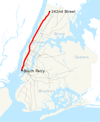
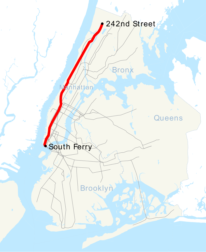
| Descrizzion | This is a map showing the New York City Subway's 1 service. It was created with TIGER/Line GIS data (water and boundaries) and my own data (subway lines and stations, traced on TIGER/Line road data). If you would like a copy of the subway data, email me. |
| Data | 30 Avril 2007 (data di caricamento originaria) |
| Sorgent | No machine-readable source provided. Own work assumed (based on copyright claims). |
| Autor | No machine-readable author provided. NE2 assumed (based on copyright claims). |
Licenza
| Mi, titolar del dirit d'autor per questa opera chì, la meti foeura in del domini publich. Questa norma chì la var in tut el mond. In d'un quai paes chesschì el podarìss vesser minga permetud de la lensg. In del cas: Mi sicuri a chissessia el dirit de drovà quell lavorà chì per qualsessia fin, sota nissuna condizzion, condamench ch'a ghe sìen di condizzion imposte de la lensg. |
Cronologia de l'archivi
Schiscia in su un grup data/ora per vedè l'archivi com 'a l'è che l'era in quell moment là
| Data/Ora | Miniadura | Grandezza | Utent | Coment | |
|---|---|---|---|---|---|
| corent | 23:45, 18 Mrz 2016 | | 648 × 792 (464 KByte) | PrecipiceofDuck | Map updated to include 7 line extension. |
| 13:01, 29 oto 2011 |  | 648 × 792 (462 KByte) | Robot8A | text to path because you can't see it properly on article | |
| 19:51, 27 sgiu 2008 |  | 648 × 792 (389 KByte) | Imdanumber1~commonswiki | Reverted to version as of 23:33, 30 April 2007; what the heck happened? | |
| 19:50, 27 sgiu 2008 |  | 648 × 792 (416 KByte) | Imdanumber1~commonswiki | == Summary == This is a map showing the New York City Subway's 1 service. It was created with TIGER/Line GIS data (water and boundaries) and my own data (subway lines and stations, traced on TIGER/Line road data). If you would like a copy of the subway da | |
| 01:33, 1 masg 2007 |  | 648 × 792 (389 KByte) | NE2 | == Summary == This is a map showing the New York City Subway's 1 service. It was created with TIGER/Line GIS data (water and boundaries) and my own data (subway lines and stations, traced on TIGER/Line road data). If you would like a copy of the subway da |
Ligámm
Quell fail chì l'è doprad de la pagina chichinscì:
Utilizazzion global di fail
Anca questi Wiki chì a dopren quell fail chì:
- Doperad in az.wikipedia.org
- Doperad in be.wikipedia.org
- Doperad in ca.wikipedia.org
- Doperad in de.wikipedia.org
- Doperad in en.wikipedia.org
- Doperad in es.wikipedia.org
- Doperad in fi.wikipedia.org
- Doperad in fr.wikipedia.org
- Doperad in he.wikipedia.org
- Doperad in id.wikipedia.org
- Doperad in ja.wikipedia.org
- Doperad in ko.wikipedia.org
- Doperad in nl.wikipedia.org
- Doperad in no.wikipedia.org
- Doperad in pl.wikipedia.org
- Doperad in pt.wikipedia.org
- Doperad in ru.wikipedia.org
- Doperad in tr.wikipedia.org
- Doperad in www.wikidata.org
- Doperad in zh.wikipedia.org