
Archivi:Karte Aut Ooe SE.png
Nissuna resoluzzion maggiora disponibil.
Karte_Aut_Ooe_SE.png (300 × 265 picsel, dimension : 4 KByte, sort MIME: image/png)
Somari
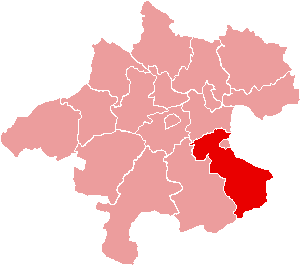
| Descrizzion | Location of Bezirk Steyr-Land within the Land of Upper Austria |
| Data | |
| Sorgent | de:Bild:Karte Aut Ooe SE.png |
| Autor | de:Benutzer:Plp |
| Permess (Doperà ancamò quell fail chì) |
GFDL-author (licence from German Wikipedia) |
| Alter version | de:Bild:Karte Aut Ooe SE.png |
Licenza

|
A l'è permess de copià, spantega e/o portagh di cambiament a quell document chì conforma ai termin de la GNU Free Documentation License, Version 1.2 o i so version vegnud adrée missa foeura de la Free Software Foundation; con tucce i sezzion che poden vesser soggette a di cambiament, senza de test de covertina e senza de test de retrocovertina . Una copia de la licenza è dent in la sezion che 'l so titol a l'èTest de la GNU Free Documentation License. |
| Quell fail chì l'è concedud in licenza sota la licenza Creative Commons Attribution-Share Alike 3.0 Unported | ||
Te gh'hee de fornì i sgiust credit, un conligament a la licenza e insegnà semai che ghe sien stad portad di cambiament. Te podet fall in una quaisevoeur manera rasgionevol, ma minga d'ona manera che la sugerissa che l'autor approva ti o la toa utilizazzion.
| ||
| Quest'eticheta chì, sora 'ldirit d'autor, l'è stada sgiontada a quell fail chì come part de l'atualizazzion de la licenza di proget Wikimedia. |
Cronologia de l'archivi
Schiscia in su un grup data/ora per vedè l'archivi com 'a l'è che l'era in quell moment là
| Data/Ora | Miniadura | Grandezza | Utent | Coment | |
|---|---|---|---|---|---|
| corent | 17:17, 23 sgiu 2006 | | 300 × 265 (4 KByte) | Physchim62 | {{Information |Description=Location of Bezirk Steyr-Land within the Land of Upper Austria |Source=de:Bild:Karte Aut Ooe SE.png |Date=2004 |Author=de:Benutzer:Plp |Permission=GFDL-autho |
Ligámm
Quell fail chì l'è doprad de la pagina chichinscì:
Utilizazzion global di fail
Anca questi Wiki chì a dopren quell fail chì:
- Doperad in bs.wikipedia.org
- Doperad in ce.wikipedia.org
- Doperad in cs.wikipedia.org
- Doperad in de.wikipedia.org
- Doperad in es.wikipedia.org
- Doperad in fa.wikipedia.org
- Doperad in fr.wikipedia.org
- District de Steyr-Land
- Gaflenz
- Modèle:Palette District de Steyr-Land
- Adlwang
- Aschach an der Steyr
- Bad Hall
- Dietach
- Garsten
- Laussa
- Losenstein
- Maria Neustift
- Pfarrkirchen bei Bad Hall
- Reichraming
- Großraming
- Rohr im Kremstal
- Schiedlberg
- Sierning
- Sankt Ulrich bei Steyr
- Ternberg
- Waldneukirchen
- Wolfern
- Weyer (Autriche)
- Doperad in fur.wikipedia.org
- Doperad in he.wikipedia.org
Varda utilizazzion global de quell fail chì.