
Archivi:Expulsion map of the Circassians in 19th century.PNG
Nissuna resoluzzion maggiora disponibil.
Expulsion_map_of_the_Circassians_in_19th_century.PNG (491 × 445 picsel, dimension : 15 KByte, sort MIME: image/png)
Somari
| Descrizzion |
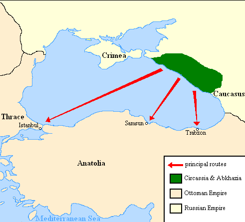
English: Map showing the location of Circassia and the expulsion routes (1859-1864) of the Circassians and other Caucasian peoples to the Ottoman Empire, after the Russian annexation of the North-Caucasus following the Crimean War of 1853-1856.
I used the information of the following two maps: http://www.circassianworld.com/CIRCASSIA1840.jpg And the books: The Northwest Caucasus: past, present, future, Walter Richmond The forgotten minorities of Eastern Europe, Arno TannerРусский: Карта с указанием местонахождения Черкесии и высылки маршрутов (1859-1864) от черкесов и других кавказских народов в состав Османской империи, после русской аннексии Северо-Кавказского следующие Крымской войны 1853-1856 гг. |
| Data | |
| Sorgent | Opera propia |
| Autor | DragonTiger23 |
Licenza
| Mi, titolar del dirit d'autor per questa opera chì, la meti foeura in del domini publich. Questa norma chì la var in tut el mond. In d'un quai paes chesschì el podarìss vesser minga permetud de la lensg. In del cas: Mi sicuri a chissessia el dirit de drovà quell lavorà chì per qualsessia fin, sota nissuna condizzion, condamench ch'a ghe sìen di condizzion imposte de la lensg. |
Cronologia de l'archivi
Schiscia in su un grup data/ora per vedè l'archivi com 'a l'è che l'era in quell moment là
| Data/Ora | Miniadura | Grandezza | Utent | Coment | |
|---|---|---|---|---|---|
| corent | 22:06, 5 Lui 2013 | | 491 × 445 (15 KByte) | Irānshahr | |
| 04:01, 4 Lui 2013 |  | 491 × 445 (15 KByte) | Irānshahr | Olahus is correct. | |
| 11:23, 3 Lui 2013 |  | 491 × 445 (15 KByte) | DragonTiger23 | Reverted to version as of 18:05, 11 February 2011 | |
| 15:23, 9 des 2011 |  | 491 × 445 (15 KByte) | Olahus | The Circassian inhabited region was actually much bigger. | |
| 20:05, 11 feb 2011 |  | 491 × 445 (15 KByte) | DragonTiger23 | {{Information |Description ={{en|1=Map showing the location of Circassia and the expulsion routes (1859-1864) of the Circassians and other Caucasian peoples to the Ottoman Empire, after the Russian annexation of the North-Caucasus following the Crimean |
Ligámm
Quell fail chì l'è doprad de la pagina chichinscì:
Utilizazzion global di fail
Anca questi Wiki chì a dopren quell fail chì:
- Doperad in bg.wikipedia.org
- Doperad in ca.wikipedia.org
- Doperad in de.wikipedia.org
- Doperad in it.wikipedia.org
- Doperad in ja.wikipedia.org
- Doperad in nl.wikipedia.org
- Doperad in pl.wikipedia.org
- Doperad in ru.wikipedia.org
- Doperad in ru.wikinews.org
- Doperad in sh.wikipedia.org
- Doperad in tr.wikipedia.org