Archivi:China map.png
Contegnûi da pàgina no suportæ in de âtre léngoe.
De Wikipedia

Fail orginal(705 × 705 picsel, dimension : 135 KByte, sort MIME: image/png)

Quell fail chì el ven de Wikimedia Commons e 'l po vesser doprad de alter proget. La descrizzion sora la soa pagina de descrizzion del fail l'è mostrada chì de sota.

Somari

Questa immagine (categorizzazione automatica: locator map) o tutte le immagini in questa categoria o galleria dovrebbero essere ricreate usando grafica vettoriale come file SVG. Questo offre diversi vantaggi: vedi Commons:Media for cleanup per maggiori informazioni. Se è disponibile una versione in formato SVG di questa immagine, per favore caricala. Dopo aver caricato un file SVG, sostituisci questo avviso con il template {{Vector version available|nome_immagine.svg}}.
Descrizzion
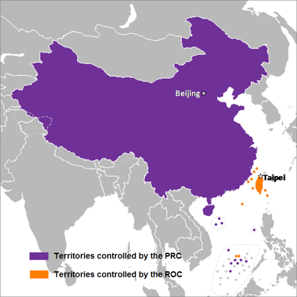
English: This is a map of the two states that officially use the name "China" in their names and depicts the actual "line of control" and not any claims that states often make. Key words: actual administration and actual maintaining of control of the territories.
中文(简体):这是一个关于两个都把“中华”用在自己的国名里的国家的地图,这个地图描绘了两国的实际“控制线”并跟两国通常声称的完全不是一回事。关键词:实际管辖和维持实际控制区域。
中文(繁體):這是一個關於兩個都把“中華”用在自己的國名裡的國家的地圖,這個地圖描繪了兩國的實際“控制線”並跟兩國通常聲稱的完全不是一回事。關鍵字:實際管轄和維持實際控制區域。
Data 24 Setember 2007 (data di caricamento originaria)
Sorgent Transferred from en.wikipedia to Commons by Sreejithk2000 using CommonsHelper.
Autor Nat di Wikipedia in ingles

Licenza

El/la Nat di Wikipedia in ingles, titolar del dirit d'autor, el/la deciara de publicala sota queste licenze chìː
GNU head A l'è permess de copià, spantega e/o portagh di cambiament a quell document chì conforma ai termin de la GNU Free Documentation License, Version 1.2 o i so version vegnud adrée missa foeura de la Free Software Foundation; con tucce i sezzion che poden vesser soggette a di cambiament, senza de test de covertina e senza de test de retrocovertina . Una copia de la licenza è dent in la sezion che 'l so titol a l'èTest de la GNU Free Documentation License.
w:pms:Creative Commons
atribuzzion
Quell fail chì l'è concedud sota la licenza Creative Commons Attribution 3.0 Unported.
Atribuzzion: Nat di Wikipedia in ingles
Te see liber:
  • de spartì con di alter persone – de copià, mandà in gir e trasmeter el lavorà
  • de organizzà de noeuv – de adatà el lavorà
Sota 'sti condizzion chì:
  • atribuzzion

Te gh'hee de fornì i sgiust credit, un conligament a la licenza e insegnà semai che ghe sien stad portad di cambiament. Te podet fall in una quaisevoeur manera rasgionevol, ma minga d'ona manera che la sugerissa che l'autor approva ti o la toa utilizazzion.

Te podet catà foeura la licenza che te voeuret

Register original del caregament

The original description page was here. All following user names refer to en.wikipedia.
  • 2008-05-29 22:44 Shibo77 705×705× (136871 bytes)
  • 2008-05-29 21:59 Shibo77 705×705× (135686 bytes)
  • 2008-05-29 21:53 Shibo77 705×705× (132630 bytes) Reverted to version as of 00:46, 16 May 2008
  • 2008-05-29 08:51 Sontung007 556×537× (31782 bytes) Reverted to the neutral version to avoid disputes and ambiguity
  • 2008-05-16 00:46 Taktser 705×705× (132630 bytes)
  • 2008-05-16 00:44 Taktser 705×705× (132710 bytes)
  • 2008-05-03 20:22 T-1000 705×705× (115888 bytes) Reverted to version as of 22:31, 4 April 2008
  • 2008-04-08 17:10 Heavyrain2408 705×705× (129360 bytes) Chinese people use tricky word "administration" to mislead readers to believe these islands belonging to them. Please stop these kinds of actions.
  • 2008-04-04 22:31 Taktser 705×705× (115888 bytes) Reverted to version as of 20:02, 27 March 2008 (administration is clearly stated, not the question of sovereignty over these territories, Arunachal Pradesh is excluded; Aksai Chin, the Spratly islands and some of the Paracel islands are included)
  • 2008-03-30 05:36 Heavyrain2408 705×705× (129360 bytes) Constroversary parts should not be included. This could result readers think that these parts belong to China.
  • 2008-03-27 20:02 Taktser 705×705× (115888 bytes) Reverted to version as of 20:31, 10 March 2008 It's clearly stated as administration not sovereignty
  • 2008-03-21 21:11 Sontung007 705×705× (129360 bytes) the previous map wrongly included unresolved disputed islands
  • 2008-03-10 20:31 Taktser 705×705× (115888 bytes) Reverted to version as of 16:33, 16 November 2007
  • 2008-01-24 15:26 Sinoevils 705×705× (129360 bytes) This is the real China Map
  • 2008-01-24 15:24 Sinoevils 705×705× (129360 bytes) This is the real China Map
  • 2007-11-16 16:33 Nat 705×705× (115888 bytes)
  • 2007-11-06 18:53 Nat 556×537× (30702 bytes)
  • 2007-11-05 22:48 Nat 556×537× (33377 bytes)
  • 2007-10-28 07:25 Jjhcap99 556×537× (31782 bytes) Added country names.
  • 2007-10-19 22:35 Jerrch 556×537× (30043 bytes) Capitalized the capitals
  • 2007-10-16 22:23 Nat 556×537× (30403 bytes) Reverted to version as of 19:37, 9 October 2007
  • 2007-10-16 20:34 Jerrch 556×537× (30411 bytes) Reverted to version as of 19:56, 29 September 2007
  • 2007-10-15 13:05 Jjhcap99 556×537× (33989 bytes)
  • 2007-10-09 19:37 Nat 556×537× (30403 bytes) This is the work of {{user|Nat}}
  • 2007-10-09 19:32 Nat 556×537× (32238 bytes) This is the work of {{User7|Nat}}.
  • 2007-09-29 19:56 Jerrch 556×537× (30411 bytes) changed color a little bit to make it just a little more neutral.
  • 2007-09-24 23:16 Nat 556×537× (30343 bytes)
  • 2007-09-24 01:44 Nat 1127×1069× (958918 bytes)
Annotations
InfoField
This image is annotated: View the annotations at Commons

Insegna

Sgionta una spiegazzion curta de cosa l'è che quell fail chì el rapresenta.

Element rapresentad in quell fail chì

representa

image/png

checksum italian

a3914e0e367e3234152db8229f8c9413a6fc7c3e

138 578 Byte

altéssa ligure

705 pixel

larghesa veneto

705 pixel

Cronologia de l'archivi

Schiscia in su un grup data/ora per vedè l'archivi com 'a l'è che l'era in quell moment là

Data/OraMiniaduraGrandezzaUtentComent
corent08:14, 15 des 2014Miniadura de la version di 08:14, 15 des 2014705 × 705 (135 KByte)Shibo77..
12:26, 2 sgiu 2010Miniadura de la version di 12:26, 2 sgiu 2010705 × 705 (134 KByte)File Upload Bot (Magnus Manske) {{BotMoveToCommons|en.wikipedia|year={{subst:CURRENTYEAR}}|month={{subst:CURRENTMONTHNAME}}|day={{subst:CURRENTDAY}}}} {{Information |Description={{en|This is a map of the two states that officially use the name "China" in their names and depicts the act

Quell fail chì l'è doprad de la pagina chichinscì:

Utilizazzion global di fail

Anca questi Wiki chì a dopren quell fail chì:

Varda utilizazzion global de quell fail chì.

Metadat