Archivi:Rødovre by night.jpg

Contegnûi da pàgina no suportæ in de âtre léngoe.
De Wikipedia

Fail orginal(4 287 × 2 222 picsel, dimension : 6 MByte, sort MIME: image/jpeg)

Quell fail chì el ven de Wikimedia Commons e 'l po vesser doprad de alter proget. La descrizzion sora la soa pagina de descrizzion del fail l'è mostrada chì de sota.

Somari

Descrizzion
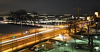
Dansk: Krydset Tårnvej/Rødovre Parkvej i Rødovre set fra Langhuset på en vinteraften. I venstre side ses den snedækkede græsplæne foran Rådhuset, i midten Rødovre Centrum og i højre side det illuminerede vandtårn.
Deutsch: Die Straßenkreuzung Tårnvej/Rødovre Parkvej in Rødovre gesehen von Langhuset aus an einem Winterabend. Links sieht man das schneebedeckte Grasstück vor dem Rathaus, im Mittel das Shopping Center Rødovre Centrum, und rechts den illuminierten Wasserturm.
English: The junction of Tårnvej and Rødovre Parkvej in Rødovre as seen from Langhuset on a winter evening. Left hand side: The snow-covered turf before the town hall. Middle section: The shopping mall Rødovre Centrum. Right hand side: The illuminated water tower.
Data
Sorgent Opera propia
Autor Bob Collowan
Permess
(Doperà ancamò quell fail chì)
This photo was taken by Bob Collowan

If possible, please credit this with: Bob Collowan/Commons/CC-BY-SA-4.0 in the immediate vicinity of the image.

If you use one of my photos outside Wikipedia and Commons, please email me (account needed) or leave me a short message on my discussion page. It would be greatly appreciated. Do not copy this image illegally by ignoring the terms of the license below, as it is not in the public domain. If you would like special permission to use, license, or purchase the image please contact me to negotiate terms.

Example:
© Bob Collowan, CC-BY-SA-4.0, Wikimedia Commons

This file has been released under a license which is incompatible with Facebook's licensing terms. It is not permitted to upload this file to Facebook.

Posission del sogeto55° 40′ 50,2″ N, 12° 27′ 12,67″ E Kartographer map based on OpenStreetMap.La posission de sta qua e de altre imagini su: OpenStreetMapinfo
Posission de la màchina fotogràfega55° 40′ 54,41″ N, 12° 27′ 06,63″ E Kartographer map based on OpenStreetMap.La posission de sta qua e de altre imagini su: OpenStreetMapinfo

Licenza

Mi, titolar del dirit d'autor, deciari de publicala sota questa licenza chìː
w:pms:Creative Commons
atribuzzion spartiss con di alter persone a l'istessa manera.
Quell fail chì l'è concedud in licenza sota la licenza Creative Commons Attribution-Share Alike 3.0 Unported
Te see liber:
  • de spartì con di alter persone – de copià, mandà in gir e trasmeter el lavorà
  • de organizzà de noeuv – de adatà el lavorà
Sota 'sti condizzion chì:
  • atribuzzion

Te gh'hee de fornì i sgiust credit, un conligament a la licenza e insegnà semai che ghe sien stad portad di cambiament. Te podet fall in una quaisevoeur manera rasgionevol, ma minga d'ona manera che la sugerissa che l'autor approva ti o la toa utilizazzion.

  • spartiss con di alter persone a l'istessa manera. – Se ti te mett insema messedand, te transformet, o te scrivet sgiò el material, te gh'hee de mandà in gir i tò contribuzzion sota la same or compatible licens come l'original.

VI seal

Questa immagine è stata valutata secondo i criteri per le immagini di valore ed è considerata l'immagine di maggior valore su Commons per l'argomento: Night photographs of Rødovre. Puoi vedere la sua valutazione qui.

Sta imagine la xe stà valutà doparando le linee guida su la qualità de le imagini e la xe considerà na imagine de qualità.

العربية  جازايرية  беларуская  беларуская (тарашкевіца)  български  বাংলা  català  čeština  Cymraeg  Deutsch  Schweizer Hochdeutsch  Zazaki  Ελληνικά  English  Esperanto  español  eesti  euskara  فارسی  suomi  français  galego  עברית  हिन्दी  hrvatski  magyar  հայերեն  Bahasa Indonesia  italiano  日本語  Jawa  ქართული  한국어  kurdî  Lëtzebuergesch  lietuvių  македонски  മലയാളം  मराठी  Bahasa Melayu  Nederlands  Norfuk / Pitkern  polski  português  português do Brasil  rumantsch  română  русский  sicilianu  slovenčina  slovenščina  shqip  српски / srpski  svenska  தமிழ்  తెలుగు  ไทย  Tagalog  Türkçe  toki pona  українська  vèneto  Tiếng Việt  中文  中文(简体)  中文(繁體)  +/−

Insegna

Sgionta una spiegazzion curta de cosa l'è che quell fail chì el rapresenta.

Element rapresentad in quell fail chì

representa

Valor minga conossud senza un element Wikidata

55°40'54.412"N, 12°27'6.631"E

55°40'50.20"N, 12°27'12.67"E

image/jpeg

Cronologia de l'archivi

Schiscia in su un grup data/ora per vedè l'archivi com 'a l'è che l'era in quell moment là

Data/OraMiniaduraGrandezzaUtentComent
corent22:04, 6 sgiu 2013Miniadura de la version di 22:04, 6 sgiu 20134 287 × 2 222 (6 MByte)Bob CollowânHigher resolution.
22:56, 23 gen 2013Miniadura de la version di 22:56, 23 gen 20132 144 × 1 111 (1,79 MByte)Bob CollowânUser created page with UploadWizard

Quell fail chì l'è doprad de la pagina chichinscì:

Utilizazzion global di fail

Anca questi Wiki chì a dopren quell fail chì: