
Archivi:Mars Viking 22a002.png

Grandezza de questa pagina de veduda antecipada: 800 × 156 picsel. Alter risoluzzion: 320 × 62 picsel | 640 × 125 picsel | 2 626 × 512 picsel.
Fail orginal (2 626 × 512 picsel, dimension : 361 KByte, sort MIME: image/png)
Somari
| Descrizzion |
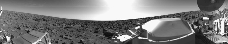
English: Original Caption Released with NASA Image: This rocky panoramic scene is the second picture of the Martian surface that was taken by Viking Lander 2 shortly after touchdown on September 3 at 3:58 PM PDT (Earth received time). The site is on a northern plain of Mars, at about 48 N. Lat., 226 W. Long., known as Utopia Planitia. The picture sweeps around 330 degrees in azimuth, starting from northwest at the left through north (above the sampler arm housing) past east, where the sky is bright at the center, and southeast toward the right above the radioisotope thermoelectric generator cover. The surface is strewn with rocks out to the horizon, ranging in size up to several meters across. Some pitted rocks resemble fragments of porous volcanic lava. Other rocks have grooves that may have been eroded by windblown sand and dust. Although fine-grained material is seen between the boulders, no sand dunes are evident. The dip in the eastern horizon at the center is an illusion caused by an 8-degree tilt of the Lander toward the west. Actually, the terrain is more level than that at the Viking 1 site. The horizon toward the left of the panorama (northwest) appears featureless, indicating that it may be several kilometers distant. The sky at the center (east) is bright because the sun was above but out of the picture at 10 AM Mars time. Toward the right (southeast), the rocks that are silhouetted against the skyline indicate that the horizon is much nearer, probably because of a slight rise in that area of the terrain. The circular high-gain antenna at the right has clots of fine-grained material adhering to the lower half, some of which appeared to have been sliding downward while the camera was scanning the area. At the extreme right, the banded appearance resulted because the camera continued to scan while it was no longer moving in azimuth. Any motion or other variation in the scene would show up as a change in successive lines. |
| Data | 2010-02-17; original photo was taken 1977-09-03. |
| Sorgent | Own work based on images in the NASA Viking image archive |
| Autor | "Roel van der Hoorn (Van der Hoorn)" |
| Permess (Doperà ancamò quell fail chì) |
I used the original 22a002.sur image from the NASA Viking image archive, converted it to .png and manually removed the noise. Except for the conversion, this was done in Adobe Photoshop CS2 and Adobe Photoshop CS4. The original file by NASA is in the public domain, and so is this new one. |
| Alter version | I created this image as a replacement for the File:Vl2.jpg. This file was created by NASA, but the quality is not very high, especially on the right side. Using the original pictures from the Lander archive resulted in a higher quality image. |
Licenza
| Quest'opera chì l'è stada missa in del domini publich del so autor, Van der Hoorn di Wikipedia in ingles. Questa norma chì la var in tut el mond. In d'un quai paes chesschì el podarìss vesser minga permetud de la lensg. In del cas: El/la Van der Hoorn el/la la sicura a chissessia el dirit de drovà quell lavorà chì per qualsessia fin, sota nissuna condizzion, condamench ch'a ghe sìen di condizzion imposte de la lensg. |
The image is based on an original image from NASA to which the following copyright statement is applicable:
| Sto file multimedial el xe 'ntel publico dominio parché el xe stà creà da la NASA. La polìtega del dirito d'autor de la NASA xe che «el material de la NASA no'l xe proteto dal dirito d'autor via de quando altrimenti spesificà». (Polìtega del dirito d'autor de la NASA e polìtega de l'uso de le imagini del JPL Image Use Policy) | ||
 |
Ocio:
|
Cronologia de l'archivi
Schiscia in su un grup data/ora per vedè l'archivi com 'a l'è che l'era in quell moment là
| Data/Ora | Miniadura | Grandezza | Utent | Coment | |
|---|---|---|---|---|---|
| corent | 02:31, 17 feb 2010 | 2 626 × 512 (361 KByte) | Van der Hoorn | {{Information |Description={{en|1='''Original Caption Released with NASA Image:'''<br />This rocky panoramic scene is the second picture of the Martian surface that was taken by Viking Lander 2 shortly after touchdown on September 3 at 3:58 PM PDT (Earth |
Ligámm
Quell fail chì l'è doprad de la pagina chichinscì:
Utilizazzion global di fail
Anca questi Wiki chì a dopren quell fail chì:
- Doperad in ca.wikipedia.org
- Doperad in de.wikipedia.org
- Doperad in en.wikipedia.org
- Doperad in es.wikipedia.org
- Doperad in fr.wikipedia.org
- Doperad in he.wikipedia.org
- Doperad in it.wikipedia.org
- Doperad in ja.wikipedia.org
- Doperad in kk.wikipedia.org
- Doperad in lt.wikipedia.org
- Doperad in ru.wikipedia.org
- Doperad in uk.wikipedia.org
- Doperad in vi.wikipedia.org
- Doperad in zh.wikipedia.org