
Archivi:M50 motorway (Ireland).png
Grandezza de questa pagina de veduda antecipada: 465 × 599 picsel. Alter risoluzzion: 186 × 240 picsel | 372 × 480 picsel | 596 × 768 picsel | 795 × 1 024 picsel | 1 490 × 1 920 picsel.
Fail orginal (1 490 × 1 920 picsel, dimension : 277 KByte, sort MIME: image/png)
.png)

|
Questo file è stato trasferito su Wikimedia Commons da en.wikipedia utilizzando uno script per bot. Tutte le informazioni riguardanti la fonte del file sono ancora presenti. Tuttavia, necessitano di un controllo umano. Inoltre, potrebbero esserci degli errori nella visualizzazione di tutte le informazioni del file, dovuti alle differenze esistenti fra i template dei progetti Wikimedia. Di conseguenza, le informazioni su questo file non dovrebbero essere considerate attendibili e il file non dovrebbe essere riutilizzato finché non è stato controllato e finché tutte le correzioni necessarie non sono state fatte. Una volta eseguito il controllo, per favore rimuovi questo avviso. Per maggiori dettagli, vedi sotto. Controlla adesso! |
.png&action=edit&withJS=MediaWiki:Botcheck.js)
| Descrizzion |
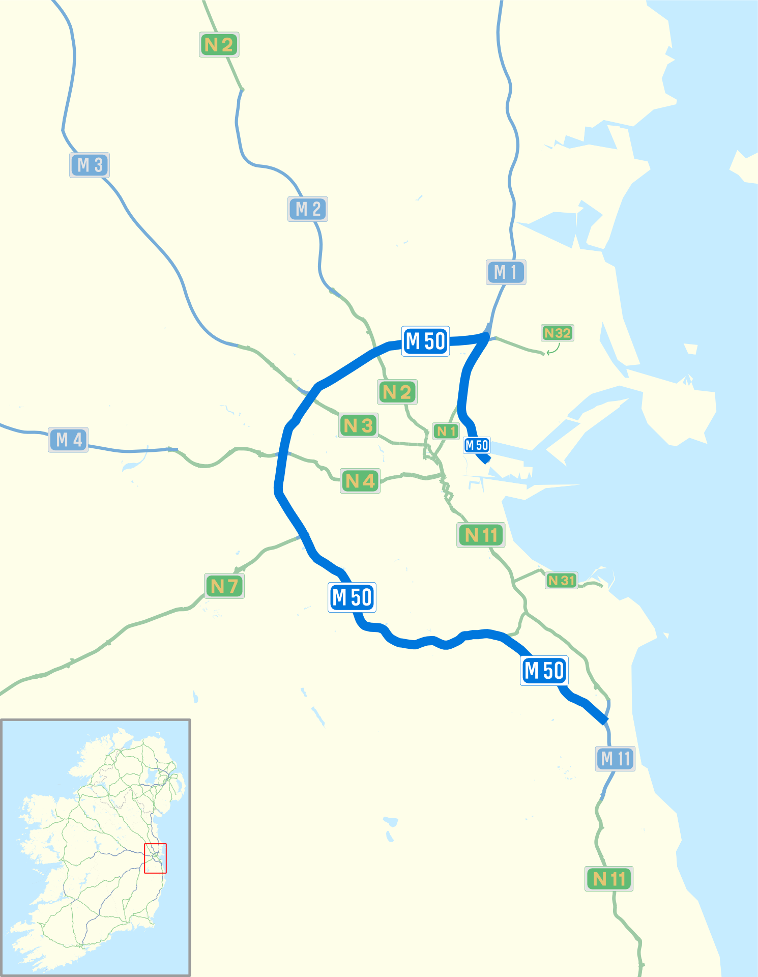
English: Map of M50 motorway (Ireland) and Dublin area roads with M50 blue bolded, Nxx routes in green and Mxx routes in blue |
| Data | (UTC) |
| Sorgent | I (Sswonk (talk)) created this work entirely by myself, using Inkscape and data from http://www.openstreetmap.org/?lat=53.41&lon=-7.7&zoom=7&layers=B000FTF which was released under https://creativecommons.org/licenses/by-sa/2.0/. |
| Autor | Sswonk (talk) |
Licenza
El/la Sswonk di Wikipedia in ingles, titolar del dirit d'autor, el/la deciara de publicala sota questa licenza chìː
Quell fail chì l'è concedud in licenza sota la licenza Creative Commons Attribution-Share Alike 3.0 Unported
Atribuzzion: Sswonk di Wikipedia in ingles
- Te see liber:
- de spartì con di alter persone – de copià, mandà in gir e trasmeter el lavorà
- de organizzà de noeuv – de adatà el lavorà
- Sota 'sti condizzion chì:
- atribuzzion –
Te gh'hee de fornì i sgiust credit, un conligament a la licenza e insegnà semai che ghe sien stad portad di cambiament. Te podet fall in una quaisevoeur manera rasgionevol, ma minga d'ona manera che la sugerissa che l'autor approva ti o la toa utilizazzion.
- spartiss con di alter persone a l'istessa manera. – Se ti te mett insema messedand, te transformet, o te scrivet sgiò el material, te gh'hee de mandà in gir i tò contribuzzion sota la same or compatible licens come l'original.
Register original del caregament
Transferred from en.wikipedia to Commons by Sswonk using CommonsHelper.
The original description page was here. All following user names refer to en.wikipedia.
- 2009-10-11 03:42 Sswonk 1490×1920× (288167 bytes) color: muted for roads and labels not highlighted
- 2009-10-08 17:57 Sswonk 1490×1920× (290544 bytes) Update shields
- 2009-10-07 03:28 Sswonk 1490×1920× (303452 bytes) {{Information |Description = Map of M50 motorway (Ireland) and Dublin area roads with M50 blue bolded, Nxx routes in green and Mxx routes in blue |Source = I ([[User:Sswonk|Sswonk]] ([[User talk:Sswonk|talk]])) created this work entirely by m
Cronologia de l'archivi
Schiscia in su un grup data/ora per vedè l'archivi com 'a l'è che l'era in quell moment là
| Data/Ora | Miniadura | Grandezza | Utent | Coment | |
|---|---|---|---|---|---|
| corent | 08:35, 5 sgiu 2010 | | 1 490 × 1 920 (277 KByte) | Sswonk | Reflect new construction as of June 2010 for M3, see http://www.transport21.ie/ |
| 04:44, 22 des 2009 |  | 1 490 × 1 920 (281 KByte) | File Upload Bot (Magnus Manske) | {{BotMoveToCommons|en.wikipedia|year={{subst:CURRENTYEAR}}|month={{subst:CURRENTMONTHNAME}}|day={{subst:CURRENTDAY}}}} {{Information |Description={{en|Map of M50 motorway (Ireland) and Dublin area roads with M50 blue bolded, Nxx routes in green and Mxx r |
Ligámm
Quell fail chì l'è doprad de la pagina chichinscì:
Utilizazzion global di fail
Anca questi Wiki chì a dopren quell fail chì:
- Doperad in de.wikipedia.org
- Doperad in en.wikipedia.org
- Doperad in ga.wikipedia.org
- Doperad in it.wikipedia.org
- Doperad in nl.wikipedia.org
- Doperad in pl.wikipedia.org
- Doperad in ru.wikipedia.org
- Doperad in sv.wikipedia.org
- Doperad in ur.wikipedia.org
- Doperad in www.wikidata.org
.png)